
[Paris 1775]. Kolor. Orig.-Kupferkarte. 25, 4 x 33, 4 cm. (Blattgr.), 22 x 28, 5 cm (Kartengr.). In sehr gutem Zustand.
Bestell-Nr: 1453-19
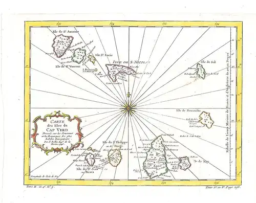
Bemerkungen: Jacques Nicholas Bellin (1703-1772). Bellin spent over fifty years at the French Hydrographic Service where he was appointed the first `Ingenieur hydrographe de la Marine`. During his term of office he carried out major surveys off all the known coasts of the world. He was also a member of the Royal societry in London. This fine hand coloured antique map of the Cap Verde Islands was published for Antoine-Francois Prevost`s monumental 20 volume edition od L`Histoire Generale des Voyages published by Pierre de Hondt, The Hague between 1747 and 1780.
Schlagworte: Karten und Pläne, Afrika
EUR 107,79 (inkl. MwSt.)Artikel eingestellt mit dem w+h GmbH oldthing-Service
Daten und Bilder powered by Buchfreund (2023-03-26)
| Gewicht in g | Homezone | Zone 1 | Zone 2 | Zone 3 |
|---|---|---|---|---|
| bis 500 | 4,00 € | 7,00 € | 8,00 € | 8,00 € |
| darüber | 8,00 € | 9,00 € | 10,00 € | 10,00 € |
| Versandkostenfrei ab Bestellwert in € |
500,00 € |